History of Hound Tor Deserted Medieval Village
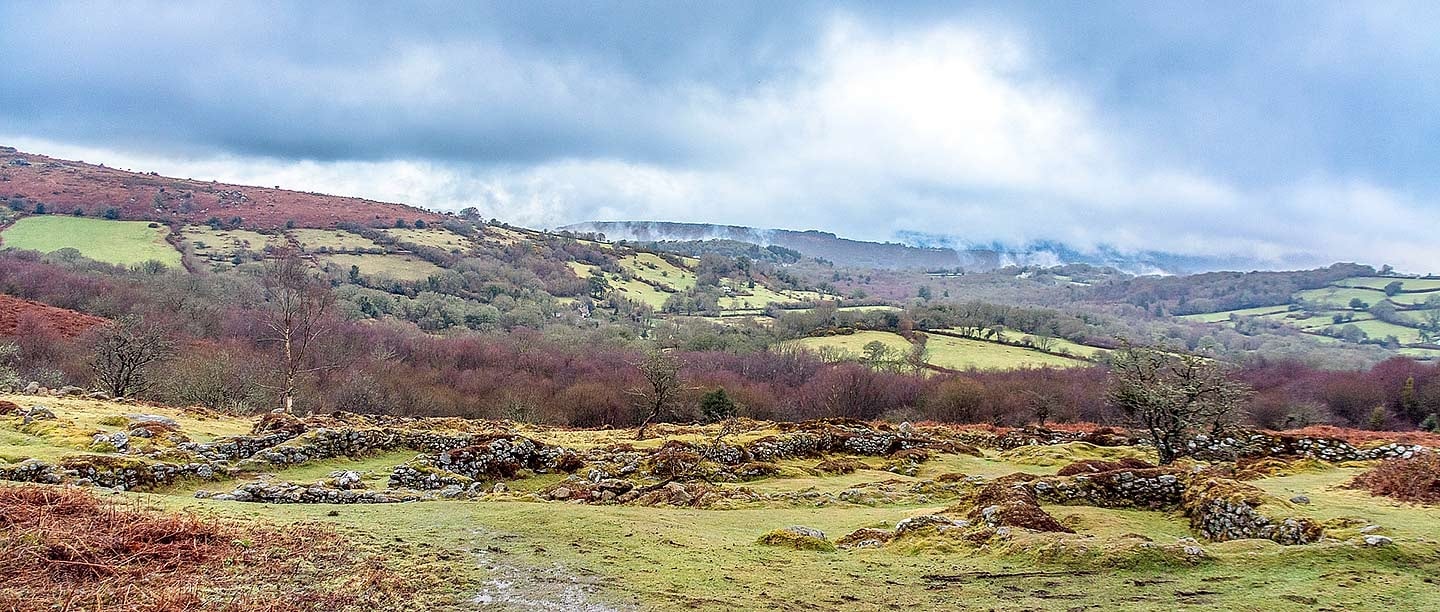
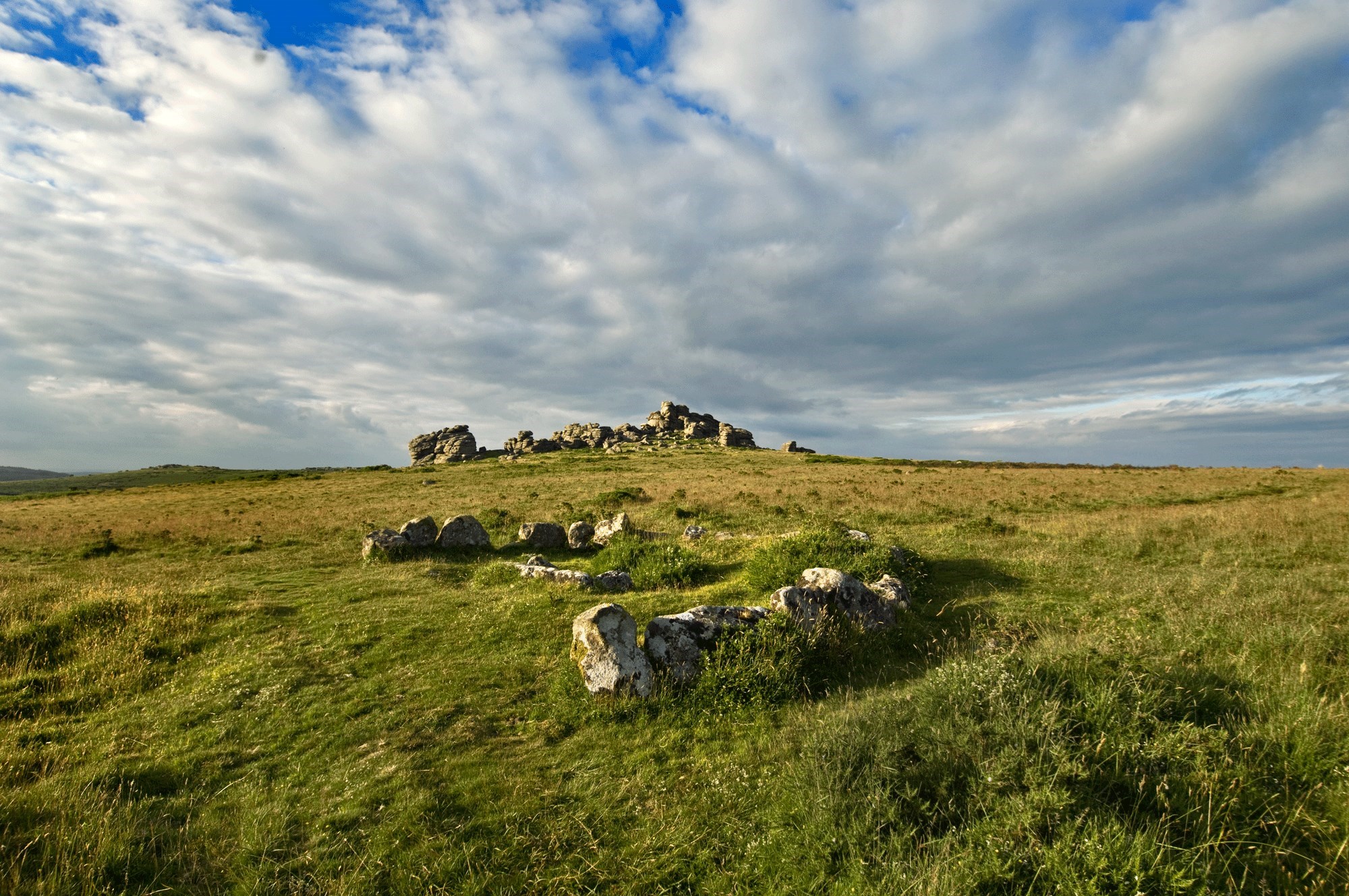
The evocative remains of this abandoned and isolated hamlet lie on the eastern edge of Dartmoor, between the granite landmarks of Hound Tor and Greator Rocks.
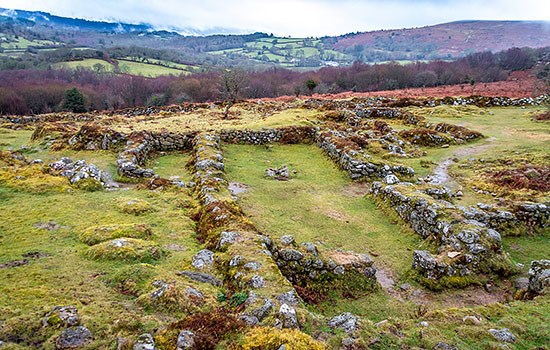
Archaeological excavations in the 1960s showed that this small and short-lived village was occupied by farmers in the 13th and 14th centuries. The hamlet had three or four main clusters of buildings, each with a longhouse, small barn and yard.
Early settlement
There are traces of circular stone huts and their fields nearby, dating from the Middle Bronze Age (1700–1200 BC). However, over-exploitation of the landscape and a cooling climate meant that year-round occupation of Dartmoor all but ceased by about 1000 BC, although the moor was still used as summer pasture for animals in the Iron Age and Roman periods.
The north European climate began to warm around the 10th century AD. Between about 950 and 1250 – a time known today as the Medieval Warm Period – average temperatures were similar to the mid 20th century. The warmer weather, and a rising population, encouraged farmers to grow crops on Dartmoor, and so live and work here the whole year.
The evidence of the great tax survey of the 1080s known as Domesday Book shows that there was a settlement called Hundetorra, named after the rocky outcrop of Hound Tor. At that date, Hundetorra was probably a dispersed settlement of isolated farms on the slopes between the rocks of Hound Tor and the village of Manaton, rather than a village with permanently occupied houses in this location. The fragmentary archaeological evidence from the site suggests that in the 11th and 12th centuries (before the hamlet of stone houses) there were huts used by shepherds and cattle farmers in the summer months.
Life in the village
The summer shelters evolved into a small farming hamlet around 1200. We don’t know the precise date, but pottery dating to the 13th century was found in the archaeological excavations, and a similar date is suggested by radiocarbon dating.
We know the names of several of the village’s lords of the manor in the 13th century. ‘Richard de Hundetorra’ was active in the first decade of the century and his son of the same name is recorded in about 1242. Richard, his household and the occupants of the other houses probably numbered about 20 or 30 villagers. Together they farmed about 10 acres (4 hectares) of arable fields around the village, divided into terraced strips running across the slope of the hill, in which they grew oats and rye.
Each of the properties had a small barn where the villagers processed, dried and stored the harvested grain. Beyond the arable fields they had the ‘outfield’ of the moor to pasture their sheep and cattle. They walked over a mile to the church in Manaton every Sunday, and they could sell their grain and buy produce in nearby Bovey Tracey and Ashburton.
Layout and buildings
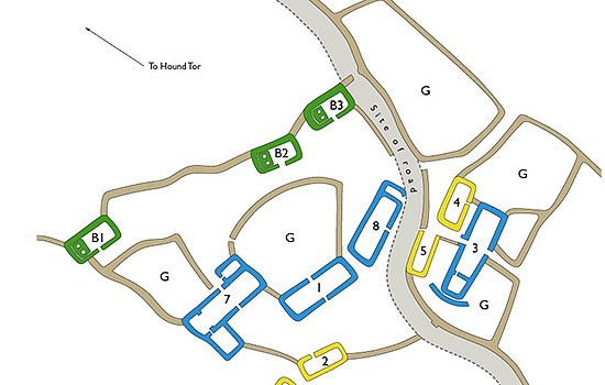
There are 11 stone buildings in the hamlet, probably organised in three farms, with another isolated farmstead about 250 metres to the north. Each group has a principal building known as a longhouse, a smaller building, a barn, and some garden and yard space.
The largest of these clusters of buildings lies in the east of the hamlet (furthest from the Hound Tor rocks) and may have been the property occupied by Richard de Hundetorra and his successors as lords of the (rather small) manor. This cluster of buildings has the largest longhouse, nearly 19 metres long, with a barn and two or three other buildings, perhaps for an older son and other family members.
All the buildings are made of local granite, with the walls once about 2 metres high. The buildings had simple thatched roofs supported on oak rafters. There would have been narrow shuttered window openings at the top of the walls, but there was no window glass. The houses were heated by an open hearth in the middle of the living area, the smoke rising up through the thatched roofs.
There are three barns on the west side of the hamlet, closest to the Hound Tor rocks. These similar buildings each have a single entrance and a pair of stone ovens at the west end. The ovens were corn dryers, used to dry the threshed grains of the harvested oats and rye to preserve them for milling and to use as next year’s seeds.
Medieval longhouses
A longhouse is a traditional rural farmhouse with one end used to house cattle in winter. This type of shared accommodation was used in many parts of northern Europe. The design ensured the mutual warmth and security of both humans and cattle during the colder months. Longhouses gradually fell out of use in most parts of England but continued to be used in Devon into the 19th century.
A longhouse was nearly always built on a slope. During winter the cattle were kept in the lower half, known as the shippon or byre, and were tethered along the walls. The shippon had a central drain to allow urine to run out of the building; the dung had to be shovelled out through a small aperture.
In the middle of the longhouse were two opposing doors connected by a passage with low wooden screens. The humans lived in the upper room, known as a livier. Larger longhouses sometimes had an inner workroom or bedroom at the highest end. This could also be arranged as a short side wing like the westernmost longhouse at Hound Tor.
Image: An artist’s reconstruction of a typical medieval longhouse, looking from the shippon towards the household’s living area (© Historic England)
The village abandoned
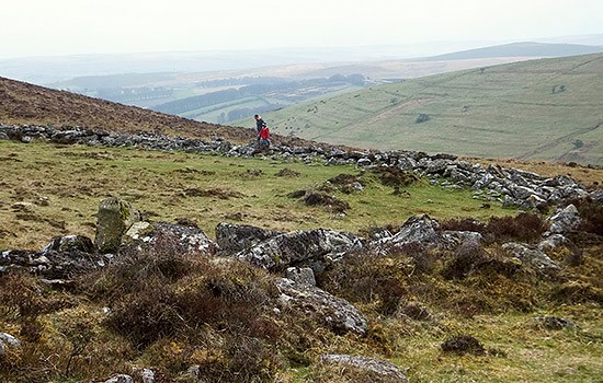
Life year-round at this altitude on Dartmoor – about 350 metres above sea level – was tough. It was probably only possible because the rocky outcrop of Hound Tor gave a little shelter from the prevailing westerly wind. But the life of the permanent settlement appears to have been short.
Unfortunately for the villagers, average temperatures slowly began to reduce in the 13th century. High rainfall caused harvest failures in 1315–17, and outbreaks of animal disease followed in 1319–20, leading to a nationwide famine. This series of events would have hit communities living on the climatic fringes – including Hound Tor – particularly badly. And worse was to come: in 1348 the global pandemic of the Black Death arrived in England, killing about half the population.
It seems likely that during the first half of the 14th century most of the surviving inhabitants of the village moved down the moor to Manaton and the lower-lying Dartmoor valleys. Pollen evidence from a nearby site shows that cereal farming declined in the 14th century. The archaeologists found late 14th-century pottery in the westernmost longhouse at Hound Tor, which suggests that some villagers clung on. But the hamlet was soon abandoned, and this part of Dartmoor returned to its traditional role as summer pasture.
Understanding the landscape
Scientific study of the Hound Tor site has yielded new information since the excavations of the 1960s.
In 1984, for example, David Austin and Michael Walker took core samples from peat deposits close to the Hound Tor village site. They analysed the fossil pollen to reconstruct how the vegetation and landscape surrounding the sample site changed over time, and obtained three radiocarbon dates to create a chronology for the pollen record. There were high quantities of cereals including oats and rye in the oldest part of their sequence, indicating arable farming in the landscape surrounding the site. This farming was already taking place when the peat accumulated in the 13th century. Cereal pollen declined in the middle part of their sequence, indicating a reduction in arable agriculture in the 14th century.
Other studies have re-examined the medieval pottery and used aerial Lidar imagery to investigate the wider landscape.
Further reading
Austin, D, ‘Dartmoor and the upland village of the south-west of England’, in Medieval Villages: A Review of Current Work, ed. D Hooke (Oxford, 1985), 71–9
Austin, D and Walker, MJC, ‘A new landscape context for Houndtor, Devon’, Medieval Archaeology, 29 (1985), 147–52
Beresford, G, ‘Three deserted medieval settlements on Dartmoor: a report on the late E Marie Minter’s excavations’, Medieval Archaeology, 23 (1979), 98–158
Butler, J, Dartmoor Atlas of Antiquities, vol. 1: The East (Plymouth, 1991)[Houndtor medieval village, fig. 8.3, pages 54–6]
Griffiths, DM (ed.), The Archaeology of Dartmoor: Perspectives from the 1990s (Proceedings of the Devon Archaeological Society 52, 1994) [includes several chapters that discuss Hound Tor]
Historic England, scheduled monument listing (accessed 10 Aug 2022)
Holata, L, et al, ‘Integration of low-resolution ALS and ground-based SfM photogrammetry data: a cost-effective approach providing an enhanced 3D model of the Hound Tor archaeological landscapes’, Remote Sensing 10:9 (2018), article 1357
Find out more
-
Visit Hound Tor
The evocative remains of this isolated Dartmoor hamlet, which was probably abandoned in the early 14th century, lie between the granite landmarks of Hound Tor and Greator Rocks.
-
Listen to our audio guide
Our audio guide is designed to be enjoyed whether you are visiting the village or just want to listen at home.
-
Dartmoor’s Historic Landscape
Find out more about all the sites that English Heritage looks after on Dartmoor, one of England’s greatest archaeological landscapes.
-
Download a plan
Download this PDF plan of the deserted medieval village to see the layout of longhouses, barns and other buildings.
-
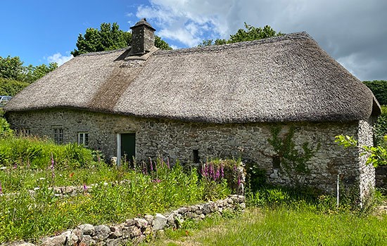
Visit a surviving longhouse
You can see a complete medieval longhouse at Higher Uppacott, which is managed by the Dartmoor National Park Authority.
-
MORE HISTORIES
Delve into our history pages to discover more about our sites, how they have changed over time, and who made them what they are today.