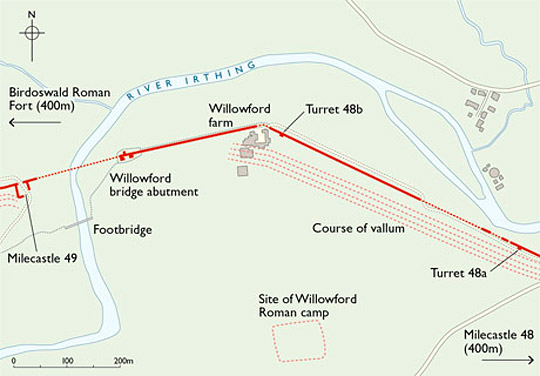
Description of Willowford Wall, Turrets and Bridge
This stretch of Hadrian’s Wall, 914 metres long, runs along the southern side of the river Irthing. The Wall itself survives for most of this length, terminating in the bridge abutment in the west and just beyond turret 48a to the east.

Wall
The Wall here stands to a maximum height of 2.8 metres west of turret 48b, but averages 1.4 metres high elsewhere. From turret 48b to the bridge it shows the base of the Broad Wall (2.8 metres wide) on its south side along its entire length. The Narrow Wall (2.2 metres wide) has been cut in behind the earlier Wall-face, the later builders, for some unknown reason, taking care to leave the earlier masonry in position.
Just west of turret 48a the Irthing has removed all traces of the Wall-ditch; the ditch is best preserved to the west of turret 48b. The Vallum (the earthwork to the south of the Wall) runs very close to the Wall here but is scarcely visible; the Military Way has never been seen in this sector, but perhaps was built over the north Vallum mound.
Turrets 48a and 48b
Turret 48a is one of the best-preserved turrets on the Wall. It measures 4.15 metres across and the north wall stands 1.85 metres high. The doorway was in the south-west wall.
Turret 48b has suffered in centuries past from its proximity to Willowford farm. It stands up to nine courses high and has lost its south wall. Built into the wall of the barn next to turret 48b is a building stone inscribed with the name of the centurion Gellius Philippus.
Both turrets were recessed farther into the width of the Wall than is the case with other turrets, which meant their front walls were comparatively thin. If they were built in the very earliest stage in the construction of the Wall, this might represent an original feature in the design of turrets which was altered as work proceeded elsewhere.
Bridge
At the west end of this sector of Wall are the substantial foundations of the bridge abutment, now some distance from the river, which has moved westwards since the Roman period.
Little remains of the original bridge, which carried the Wall across the river. The base of a tower, which gave access to the bridge from ground level, and splayed abutment foundation, are the only survivals of this first phase. The length of the Wall into which the tower was recessed is of broad gauge, proof that the bridge belongs to the first stage in the building of the Wall.
The massive rectangular foundation further west (nearest to the river), separated from the abutment by a narrow channel, represents the first pier of the later, wider bridge, designed to carry both the Wall and Military Way. The bridge was constructed of stonework bonded with dovetail and bar cramps. Holes for the cramps are visible in the outer stone pier of the original pair of narrow culverts.
Worth noting are the many reused blocks in the later tower and abutment wing walls. They include fragments with mouldings, indicating that the bridge, though built on a more modest scale than that at Chesters, was not without architectural pretensions.
READ MORE ABOUT WILLOWFORD WALL, TURRETS AND BRIDGE
