
History of St Catherine’s Castle
Perched on a rocky promontory at the mouth of the river Fowey, St Catherine’s Castle formed part of a chain of defences built in the reign of Henry VIII (1509–47) in the face of threatened invasion from France and Spain. Its purpose was to prevent seaborne attacks on the important mercantile port of Fowey.
After the initial threat had waned, the castle continued to be used intermittently in response to new dangers. Much later, it was significantly modernised, first between 1855 and 1858 – when it became known as Fowey Battery – and then during the Second World War.
The Tudor castle
Early in 1539, Pope Paul III arranged a treaty between Francis I, King of France, and Charles V, the Holy Roman Emperor, temporarily ending years of hostility. He urged them to invade England to punish Henry VIII, who had angered him by divorcing Katherine of Aragon, taking control of the Church in England, and destroying the monasteries of England and Wales, appropriating their lands and revenues.
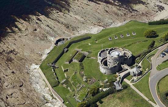
Although St Catherine’s Castle formed part of Henry VIII’s response – a national programme of defence anticipating that invasion – it was funded and supervised by a leading townsman. The wealthy and influential Thomas Treffry, of nearby Place House, was also involved with building St Mawes Castle shortly afterwards, at the mouth of the river Fal.
Treffry built the castle on a steep, rocky site on the west side of the river Fowey, where it enters the sea. The river is only about 230 metres wide at this point, making any ships attempting to enter the river an easy target for the castle’s guns.
St Catherine’s Chapel
St Catherine’s Point, the headland on which the castle stands, was named after the medieval chapel dedicated to St Catherine that once stood at its highest point. The chapel no longer survives, but was still standing in 1539 when the castle was built. St Catherine was a Christian martyr, executed for her beliefs by order of the Roman emperor Maxentius (r. AD 306–12), and venerated throughout the Middle Ages.
The chapel, perched high on the headland, was perhaps a place where seafarers could pray and give thanks for undertaking and surviving perilous journeys. It may also have had a navigation light and bell to help them find the entrance to the river Fowey in bad weather.
Today, a Victorian mausoleum occupies the site of the chapel. Members of an influential local family, William and Catherine Rashleigh and their daughter Edith, are buried there.
Image: St Catherine of Alexandria, depicted in 14th-century stained glass now at Ely Cathedral Stained Glass Museum, Cambridgeshire. She is shown holding the spiked wheel and sword with which she was tortured and martyred
© Holmes Garden Photos/Alamy Stock Photo
The Tudor gun tower
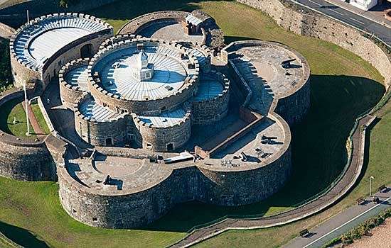
The builders excavated areas of bedrock to create platforms for the fort’s structures, which comprised three main elements: an upper gun tower (the ‘castle’), a gun platform below it (the ‘lower battery’) and a defensive wall. This wall reached right across the headland north-east and south-west from the gun tower, to make the whole castle defensible against a landward attack.
St Catherine’s Castle, showing the Tudor gun tower at the centre, the lower battery below it, and the north-east section of the defensive wall to the right of the gun tower. The gun tower’s entrance is beside the flagpole; also visible are its ground-floor embrasures, one embrasure and three windows at first-floor level, and the ruinous parapet level
The gun tower was the strongpoint of the castle in Tudor times. It is D-shaped and contained three floors. The ground floor has a pointed arched doorway; three arched embrasures (openings) in the walls (one now blocked up) for guns at floor level; and a fireplace with a chimney in the north-west wall. The north-east wall is formed from cut-back bedrock.
On the first floor were another seven arched openings. One is like those on the ground floor, for a gun at floor level; the others are taller, narrower and more window-like, but suitable for muskets and heavier guns mounted on swivels to help with aiming. One of these is also blocked up. In the north corner, a winding stair in the wall ascends to the second floor. The blocked-up opening beside it in the north-east wall may have been a doorway leading into the first floor from the defensive wall outside.
The second floor was open to the sky and incorporates a stone-flagged sentry walk. It may have had a crenellated parapet, and its floor was probably planked and covered in lead. This lofty position gave a wide view of the sea for those on watch and made an ideal fighting platform for soldiers firing handguns and longbows.
. It shows the gun tower (top), the lower battery with two gun embrasures (dark coloured, centre left) and the defensive wall between them")
The lower gun platform
Below the gun tower, on a lower platform in the rock, is a Victorian gun battery. An 18th-century illustration shows an earlier battery in the same location, and it is likely that there was one here in Tudor times. While the gun tower could only have contained light or medium guns, a lower, open-air battery could have supported heavy guns with a wider field of fire, capable of sinking ships. The battery that fought a Dutch 70-gun frigate in 1666 must have been here.
The defensive wall
A stone wall attached to each side of the gun tower, aligned north-east to south-west, separates the castle on the point from the rest of the headland. The wall formed a defensible barrier against attempts to storm the castle from the landward side. It is built on steep slopes and ends on rock faces too severe to climb. Towards its centre point it forms a rectangular projection towards the land: this was probably to enable defenders to fire along the faces of the wall, including the entrance near the north-east end.
It is likely that the wall originated in Tudor times but was altered subsequently. It is depicted as being stepped and crenellated (on the north-east section only) on a later 18th-century illustration.
The castle in action
The castle was probably armed during emergencies in the Tudor era, and also in the First Civil War (1642–6), when Fowey was held in turn by the opposing forces of Parliament and the Crown.
As far as we know, the gunners of St Catherine’s Castle saw action only once, during the Second Anglo-Dutch War (1665–7). In June 1666 a 70-gun Dutch warship entered the river in pursuit of a convoy of English merchant ships that had sailed across the Atlantic from Virginia. The castle guns, along with others across the river in Polruan, exchanged fire with the warship for about two hours. It proved to be a successful defence, as the warship was damaged and forced to retreat to the open sea.
The action against the Dutch must have been fought with cannon on the lower battery, because any weapons in the gun tower would have been too small and with too restricted a field of fire to fight a 70-gun ship. Francis Grose’s late 18th-century watercolour (above) shows the lower battery defined by an earthen parapet with gun embrasures.
War with France
Around 1793, after the outbreak of war between Britain and Revolutionary France, a group of about 60 ‘Battery Men’ formed. They practised on ten old guns which, in 1796, were grouped in three batteries on the west side of the river. Five of these guns were on the lower battery at St Catherine’s Castle and the others in two batteries further upstream.
A formal Fowey Volunteer Artillery Corps was established in 1797, responding to the threat of a possible French invasion. They were active throughout the conflict with France but were disbanded, and all the batteries disarmed, at the end of the war in 1815.
Victorian revival: Fowey Battery
In the early 1850s, there was growing concern about renewed French military expansion and the unpreparedness of British coastal defences. This resulted in re-armament and the building of new defences, including at important mercantile ports such as Fowey.
In 1855, the War Department bought the land on St Catherine’s Point, and in the following year began to construct emplacements for two guns on the site of the lower battery. By 1858, two 32-pounder smooth-bore guns were in place and in 1859 the 3rd (Fowey) Cornwall Artillery Volunteers, a new part-time unit, took over Fowey Battery. New, more powerful 64-pounder rifled guns were installed in 1873. From 1890 it became a drill and practice battery, not permanently manned, and it remained in use until the guns were withdrawn in 1899–1900.
The two Victorian emplacements survive and have curving low walls with granite capstones and sloping ‘aprons’ to the front, designed to deflect incoming shot over the gunners’ heads. Each emplacement has a central steel pivot around which a wooden platform with small trucks (wheels) rotated on the two steel racers (rails). This made for easy movement and aiming of the guns. The gun carriage was a sliding type: the recoil force of firing made it slide up the inclined gun platform to a retired position for reloading.
There were two small gunpowder magazines. One was just behind the guns along with a store building, and the other was built inside the old gun tower, in the north corner of the ground floor. A wide vertical groove cut into the rockface shows where one of its walls was inserted.
The defensive wall may have been repaired and modified at this time, with reformed loopholes for muskets and a remade entrance.
An author’s inspiration
The author Daphne du Maurier (1907–89) loved the Cornish landscape, and in 1926 her family bought a holiday home, Ferryside, at Bodinnick, further up the river Fowey. A local lady later recalled that, as a girl of ten in 1930, she would walk with Daphne ‘to St Catherine’s Castle, sit on the old armament bases and admire the magnificent view back up the Fowey River’.
In 1941–2 du Maurier rented Readymoney Cottage near St Catherine’s Castle, before moving just two miles in 1943 to Menabilly, the ancestral home of the Rashleigh family. This was the house which had inspired Manderley in her 1938 novel Rebecca, and was where she wrote many of her books.
Image: Daphne du Maurier in 1930
© National Portrait Gallery, London

A new emergency
By June 1940, during the initial stages of the Second World War, the failure of Allied forces in western Europe had created a front line along the British coast. As part of a huge programme of defence against an expected German invasion, numerous coastal gun positions – ‘emergency batteries’ – were built with great speed. This included one at Fowey, which was armed and ready by mid-August. The battery formed part of extensive defences at Fowey, which was at the southern end of a ‘stop line’ extending across Cornwall to the north coast at Padstow and designed to prevent the progress of any German force that had landed.
As part of the battery the military engineers built two gun houses, magazines, shelters, stores, an observation post and searchlights, all camouflaged, across the headland. They adapted one of the empty Victorian gun emplacements for one of the battery’s two 4.7-inch guns, with an adjacent shelter for the gunners.
The guns were operated by two regular Royal Artillery units, 364 Coast Battery until September 1942 and 379 Coast Battery afterwards, with about 75 men in each. Neither unit saw action, and the battery was closed by the end of October 1945.
The Tudor gun tower was also repurposed during the Second World War, by staff from the Royal Navy, who used it to control a minefield just outside the entrance to the river. The mines were tethered to the seabed in known positions. If an enemy vessel approached, mines could be detonated to damage or sink it via an electrical signal sent along a cable between the observing station in the gun tower and the minefield.
Most of the 1940s structures on the headland were removed after the war but traces and foundations remain, partly concealed by undergrowth, along with one entire building (the WC block).
By Paul Pattison
Find out more
-

Visit St Catherine’s Castle
Discover what is perhaps Cornwall’s smallest castle, perched in a spectacular setting at the mouth of the Fowey estuary.
-
Visit St Mawes Castle
St Mawes Castle, perched across the bay from Pendennis Castle, offers a stunning counterpoint to its larger sibling across the river Fal.
-
Tudor Warfare
The Tudor period saw the gradual evolution of England’s medieval army into a larger, firearm-wielding force supported by powerful ships and formidable gun forts.
-
MORE HISTORIES
Delve into our history pages to discover more about our sites, how they have changed over time, and who made them what they are today.