History of Knowlton Church and Earthworks
Not many parish churches stand in ruins, and fewer still occupy sites associated with prehistoric rituals. Four thousand years separate the main late Neolithic earthwork at Knowlton and the Norman church that stands at its centre. The earthwork itself is just one part of a landscape which is one of the great Neolithic and Bronze Age ceremonial complexes in southern England.

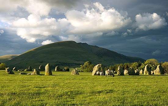
The main earthwork at Knowlton is of a type known as a henge. There are nearly one hundred henges in Britain and Ireland, dating from about 3000 to 2000 BC. Although they are generally believed to have been ceremonial sites, it is likely that they fulfilled many functions, and may have changed their role through time.
Church Henge, as it is now known, has been protected from plough damage; the earthworks in the surrounding landscape have been less fortunate, but are still clearly visible in aerial photographs.
There are three other main earthworks nearby: the Northern Circle and ‘Old Churchyard’ (both to the right of Church Henge in the photograph); and the Southern Circle, which encloses Knowlton Farm (top left), and is surrounded by a ditch 240 metres (790 feet) in diameter.
Nearby Barrows
Associated with this group of henges is one of the greatest concentrations of round barrows, or burial mounds, in Dorset.
The clump of trees 60 metres (200 feet) to the east of Church Henge marks the enormous Great Barrow, the largest individual barrow in the county.
Many other barrows and ring-ditches survive within a one-mile radius: stretching away to the north-west, for example, is the Dorset Cursus, twin banks of chalk about 2 metres (6 feet) high running for over 9km (6 miles), defining another zone in this ceremonial landscape.
The high number and diversity of prehistoric and later archaeological remains surviving in this area of chalkland, known as Cranborne Chase, is partly due to the later history of the Chase as a royal hunting ground from at least Norman times, which meant that land use was strictly controlled.
The Church
The church was built in the 12th century and was in use until the 17th century, serving a now vanished hamlet by the riverside. Its Norman origins are evident from the plain round arch leading into the east end or chancel, and from the round-headed arches of the arcade dividing the nave from the north aisle. The south door also looks Norman.
The tower at the west end is 15th century, and is built of flint with bands of stone; the line of the church roof is clearly visible on its eastern face. At the east end of the north aisle there appears to have been a lady chapel.
Whatever the reason for building a church within a Neolithic henge, the curious pairing has undoubtedly contributed to the survival of both, as an enduring symbol of the transition from pagan to Christian worship.
Further Reading
Burl, A, Prehistoric Henges (London, 1991)
Burrow, S and Gale, J, ‘Survey and excavation at Knowlton Rings, Woodland Parish, Dorset, 1993–5’, Proceedings of the Dorset natural History and Archaeological Society, 117 (1995), 131–2