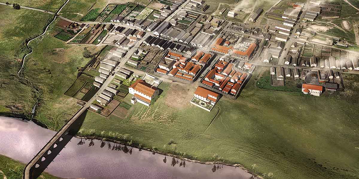
Description of Corbridge Roman Town
The exposed English Heritage site (about 1.8 hectares) represents only a tiny fraction – the central nucleus – of the Roman town built around the site of successive forts. The entire site (still extant, though thoroughly levelled by agriculture) is known from aerial photographs and pre-First World War excavations to cover roughly 15–20 hectares in the surrounding fields.

Setting
Roman Corbridge lies on a gently rounded elevation above the Tyne. The ground falls steeply to the river to the south, gently to the Cor Burn to the west, and to the north is level before rising to Hadrian's Wall, 2½ miles distant.
The site lay at the junction of Dere Steet – the main Roman road north, which bridged the Tyne just west of the site – and the Stanegate, the road west to Carlisle. Dere Street entered the town west of the visible remains. Anyone travelling north to the Wall, or Scotland, had to traverse the site east along the visible main street, the Stanegate, before turning north again east of the exposed area.
Early Forts at Corbridge
No remains of the early forts which underlie the later town are visible except for some walls within the courtyard building (Site XI). These represent part of the latest (mid-2nd-century) fort headquarters, and, to its east, the commanding officer's house.
The Stanegate follows the line of the main east–west road inside the forts. The side street between the two later compounds south of this road perpetuates the line of the via praetoria of the successive forts, leading south from the headquarters to their front gate.
The modern museum building marks the line of the west rampart of the early forts. Their eastern side lay near the opposite (eastern) side of the fence enclosing the site.
Town
The main street, now seen in its 3rd- and 4th-century state, forms one of the most easily recognisable landmarks among the exposed remains. It separates the vast Site XI, a fountain and granaries on its north side from the complicated remains of the legionary compounds to the south.
Site XI, covering 67 by 65.5 metres, is built of massive, tightly fitting blocks without any use of mortar. The masonry is of high quality. The blocks have conspicuous projecting bosses, a common sight on Greek and Roman buildings in the Mediterranean, but the edges of all the blocks have been carefully dressed to ensure a tight fit with their neighbours.
Only the street frontage and part of the side ranges of the building were ever completed – the foundations in the northern half have never been dressed flat to take upper courses. The wide entrances to the rooms suggest that goods were sold from here and not merely stored.
The two granaries to the west are the best preserved in Britain, with their raised floors and underfloor ventilators surviving intact. The columns at the front supported a portico protecting the loading bays from the weather; their bases were buried by the gradual raising of the Stanegate in the 3rd and 4th centuries.
Between Site XI and the granaries an aqueduct embankment leads to the back of a public fountain. The sides of the public trough have been worn down – perhaps not, as is often claimed, by the sharpening of knives, but by generations of inhabitants washing clothes.
On the south side of the road can be traced the meandering walls and internal buildings of two compounds (later amalgamated), probably built in the early 3rd century for detachments from the Second and Sixth Legions. Each contains its own headquarters building; these face each other from opposite ends of a carefully planned visual axis.
READ MORE ABOUT CORBRIDGE ROMAN TOWN