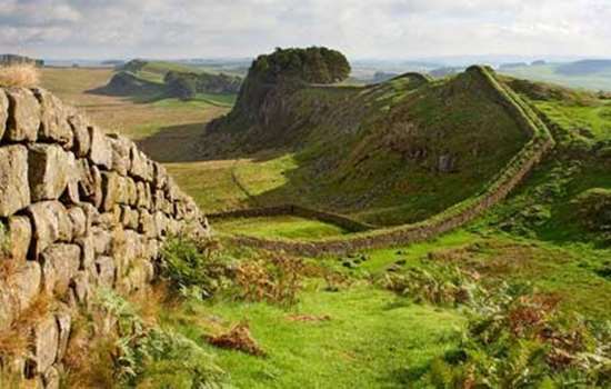
History of Harrows Scar Milecastle and Wall
Hadrian’s Wall, begun in AD 122, was originally built of turf from the western end of the Wall at Bowness on Solway as far as Harrows Scar Milecastle. This turf structure was later replaced in stone. Between Harrows Scar Milecastle and the Roman fort at Birdoswald, 400 metres to the west, a length of the Wall survives up to 2 metres high, and contains a number of Roman inscriptions and phallic symbols that have been left in place. This part of Hadrian’s Wall has played an important role in understanding the Wall’s building sequence.

The Turf Wall and Milecastle
The building of Hadrian’s Wall began in AD 122. The first plan for the Wall provided for a stone Wall running from Wallsend at its eastern end to the river Irthing at Willowford, and then for a turf Wall from Harrows Scar (milecastle 49), on the high western bank of the Irthing, to Bowness on Solway.
This turf Wall was built on a flat base that consisted either of several layers of turf, as seen in the most completely preserved section to be excavated at High House (turf Wall milecastle 50),[1] or of cobbles, as at Burgh-by-Sands (milecastle 72).[2] The base of the Wall was normally some 6 metres wide.
At High House, evidence suggests that the southern side of the Wall sloped at an angle of about 1:4, while the north face was almost vertical towards the base, perhaps changing to a more gentle slope higher up. The height of the turf Wall has been estimated at some 3.66 metres.
Though we call it the turf Wall, in some places it was only the face that consisted of laid turves, while the infill might be of earth or, sometimes, of clay and other materials.[3] Where turf was available for building it was clearly stripped from the areas to the north and south of the Wall.[4]
As in the case of the stone Wall it is not certain how the top of the turf Wall was treated. In an influential reconstruction drawing of 1934, the Wall is shown topped by a boardwalk and a breastwork (a vertical screen) of split timber.[5] Evidence from pollen analysis at Appletree, however, indicates that any breastwork would more probably have consisted of hurdles woven from thin branches of birch and alder that grew in scrub woodland in the area.[6]
Turf Wall milecastles were built using the same construction method as the Wall itself. Like the milecastles of the stone Wall, gates were provided in the northern and southern walls. The north gates had timber towers built over them.
Harrows Scar Milecastle is one of the few turf Wall milecastles to have been excavated.[7] It was orientated with its short axis along the Wall. The turf walls were 6.10 metres wide and enclosed an area measuring 14.46 by 15.24 metres. No trace was found here of an internal building, but it has been shown elsewhere that such buildings were made of timber.
The Stone Wall and Milecastle
The stretch of turf Wall from Harrows Scar west to milecastle 51 (Wall Bowers) was replaced in stone before the end of Hadrian’s reign (AD 138). The stone Wall diverged from the line of its turf predecessor, however – the only place on the Wall where this occurs – in order to meet the northern corners of the stone-built fort at Birdoswald.
At the same time, the milecastle too was rebuilt in stone and now measured 22.86 by 19.81 metres internally. The south gate was rebuilt and narrowed using a hard white mortar that is associated with early 3rd-century work on the Wall. This rebuilding incorporated a crudely carved stone showing Mars and Victory.[8]
Although Roman-period layers did not survive well in the milecastle, it can be assumed that occupation on such an important river crossing would probably have lasted until the late 4th century.
The Post-Roman Period
The milecastle clearly remained visible for a long time. It had been reused by 1603, when it was part of the land tenanted by Henry Tweddle, who had ‘a cottage and Yarde … by the said Wall north, butting east upon Irdinge’.[9] This is a clear reference to a post-medieval building whose foundations were excavated in 1956.[10]
READ MORE ABOUT HARROWS SCAR MILECASTLE AND WALL
About the Author
Tony Wilmott has recently excavated at Birdoswald Roman Fort and is a leading authority on Hadrian’s Wall. He is the author of the English Heritage Red Guide to Birdoswald.
Footnotes
1. FG Simpson, IA Richmond and K St Joseph, ‘2. The turf wall milecastle at High House’, in ‘Report of the Cumberland Excavation Committee for 1934: excavations on Hadrian’s Wall’, Transactions of the Cumberland and Westmorland Antiquarian and Archaeological Society, new series, 35 (1935), 220–29.
2. PS Austen, ‘Recent excavations on Hadrian’s Wall at Burgh-by-Sands’, Transactions of the Cumberland and Westmorland Antiquarian and Archaeological Society, new series, 94 (1994), 35–54.
3. DJ Breeze, The Northern Frontiers of Roman Britain (London, 1982), 76.
4. T Wilmott and J Bennett, ‘The linear elements of the Hadrian’s Wall complex: four investigations 1983–2000’, in Hadrian’s Wall: Archaeological Research by English Heritage 1976–2000, ed T Wilmott (Swindon, 2009), 118 (accessed 8 June 2015).
5. Simpson et al, op cit.
6. T Wilmott, Birdoswald Roman Fort: 1800 years on Hadrian’s Wall (Stroud, 2001), 44.
7. IA Richmond, ‘Excavations at Milecastle 49 (Harrows Scar)’, Transactions of the Cumberland and Westmorland Antiquarian and Archaeological Society, new series, 56 (1956), 18–27.
8. JC Coulston and EJ Phillips (eds), Corpus Signorum Imperii Romani: Corpus of Sculpture of the Roman World – Great Britain, vol 1, fascicule 6: Hadrian’s Wall West of the North Tyne and Carlisle (Oxford, 1988), no 75. The stone is still in situ, but is now buried.
9. THB Graham, The Barony of Gilsland: Lord William Howard’s Survey taken in 1603, Cumberland and Westmorland Antiquarian and Archaeological Society Extra Series 16 (Kendal, 1934).
10. Richmond, op cit.