History of Skipsea Castle
The Norman castle at Skipsea, built in about 1086, was the residence and administrative centre of the lords of Holderness. William the Conqueror created the lordship of Holderness, a vast area from the Humber estuary to Bridlington. He gave it to Drogo de la Beauvrière, who had fought alongside him at the Battle of Hastings in 1066. The king needed a trusted follower there to control the area and the adjacent coastline.
Recent research has revealed that the mound at Skipsea, previosuly thought to be a motte created by the Normans, dates from the Iron Age.

The earlier stages of the mound are now known to be of Iron Age date – probably a burial mound. This was later adapted as a medieval motte.
Drogo de la Beauvrière built Skipsea Castle as a principal residence and his successors, the Counts of Aumale, held the seat for the next 130 years. The castle would probably originally have been built from timber, and later rebuilt in stone.
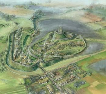
The motte and bailey would have been vulnerable to attack from the higher ground. To guard against this, in the 12th century Count William le Gros created a fortified settlement or ‘borough’, possibly located on the ridge and known as Skipsea Brough like the modern settlement. Its houses and shops fronted onto a roadway and it provided him with an income from tolls and rents. It was enclosed within a massive earth rampart which also encompassed the main through route descending to the easiest crossing of the marshy ground.
Today, it is difficult to understand why a castle was built in this apparently remote area. Evidently the route crossing the marsh must have been more important in the Middle Ages. The small coastal port that the lords of Holderness tried to develop nearby failed to thrive and there is little evidence to suggest that the town on the ridge proved any more successful: there are few traces of buildings. Ultimately, neither town nor castle was sufficiently well sited to encourage its continued use.
Use of the castle declined from about 1200 when the lords of Holderness moved their administrative residence to Burstwick. The castle was ordered to be destroyed in 1221 when Count William de Forz II rebelled against the king. By 1350 the castle was being leased for pasture and the borough was abandoned.
Landscape Setting
Motte-and-bailey castles of this type are not rare, but Skipsea’s conical mound is exceptionally large – 278 feet (85 metres) in diameter and 42 feet (13 metres) high. It has long been assumed to be of Norman origin, but has recently been identified as an Iron Age earthwork. Analysis of datable material extracted by drilling a borehole through the mound has revealed it to be 2,500 years old, and therefore the largest Iron Age mound in Britain.
The marshy ground surrounding the motte is natural, although recent research by English Heritage suggests that an earth dam (probably constructed at the same time as the castle) was added to trap more water, creating Skipsea Mere. This large, shallow lake would have served as a defence, as a fish pond and as an ornamental feature.
Description
Visitors approach through the gate and walk up to the brow of the ridge. The motte, surrounded by a low rampart, can be seen ahead to the north. The bailey was in front of this but parts of its defences are now difficult to distinguish as a result of later ploughing. The defensive bank that surrounded the borough, to the left, remains more obvious. The mere lay behind the motte and would have extended into the natural channel along the foot of the ridge, separating the borough from the bailey.
A relatively recent cutting along the farm track leads through a mound which possibly marks the site of a gate tower. This would have been built to control access into the bailey. The main gate is thought to have faced south-east towards the church, with the main street of Skipsea aligned on it.
Further Reading
Beresford, M, New Towns of the Middle Ages: Town Plantation in England, Wales and Gascony (London, 1967)
Butler, R, ‘Skipsea Brough’, Archaeological Journal, 141 (1984), 45–6
Pounds, NJG, The Medieval Castle in England and Wales: A Social and Political History (Cambridge, 1990)Renn, D, The Norman Castle in Britain (London, 1968)


