
History of Planetrees Roman Wall
The Romans built Hadrian’s Wall from AD 122 at the northern edge of the province of Britannia, marking the north-west boundary of their empire. A 35-metre long section of the Wall that narrowly escaped total destruction in the 19th century is preserved at Planetrees, on a gentle slope at the eastern edge of the North Tyne valley.
This small section of the Wall, about 27 Roman miles (40km) from its eastern end, reveals an important change to the construction plan that was made while work was in progress.
The design of Hadrian’s Wall
The original design for Hadrian’s Wall comprised a continuous wall about 4.5 metres high, with a V-shaped ditch along its north side, extending for 80 Roman miles (117.5km) from Wallsend on the river Tyne in the east to Burgh-by-Sands on the Solway Firth in the west.
The Wall included about 160 watchtowers or ‘turrets’, providing vantage points to monitor movements of people, especially to the north. Pairs of turrets were positioned equidistantly between small forts, or ‘milecastles’, where small garrisons of between 8 and 30 soldiers guarded gates that allowed access through the Wall.
During construction of the Wall, the Roman authorities decided to incorporate large forts such as Chesters, Housesteads and Birdoswald into it. These could accommodate larger forces of about 500 or 1,000 soldiers in each.
A change of plan
The original intention was for Hadrian’s Wall to be about 10 Roman feet (2.96 metres) wide. Building the foundation proceeded quickly, but raising the Wall itself was slower. This forced a reduction in the Wall’s width to between 6 and 8 Roman feet (1.8–2.37 metres), presumably to speed up construction.
This change of plan is visible at Planetrees. The eastern 15 metres of Wall here are broad, but an inward step in the south face reduces the width of the western 20 metres to only 1.8 metres. This junction may also differentiate the work of two adjacent construction teams.
Westwards, descending into the North Tyne valley, the Roman army completed the Wall at the narrow width on a broad foundation that had been completed before the decision to narrow the Wall was taken.
Sixty metres south of the Wall at Planetrees is evidence of another alteration to Hadrian’s Wall, made during its construction but before the addition of the large forts. Parallel to the Wall here is a shallow ditch, which was part of the vallum – a broad, flat-bottomed ditch flanked by banks, which demarcated the rear of a military zone between it and the Wall and extended along the entire frontier. Though now reduced and infilled by centuries of ploughing, the ditch is still clearly visible here.
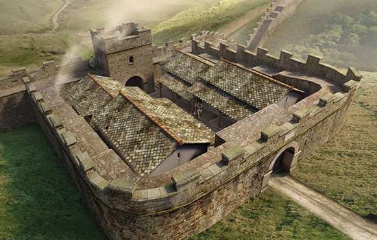
Hadrian’s Wall at Planetrees, as it may have appeared during construction. The soldiers of the Roman legions didn’t just fight; they were also skilled builders. At the top of the slope on the right side of the image, milecastle 26 is being built.
© Historic England/English Heritage Trust (illustration by Peter Urmston)
Saving the Wall at Planetrees
The survival of this short stretch of Wall may be owed to the intervention of one man, William Hutton (1723–1815). In 1801, at the age of 78, Hutton walked the length of Hadrian’s Wall, also walking from his home in Birmingham and back – a total of 600 miles.
During his journey along the Wall, Hutton arrived at Planetrees to find a labourer in the process of dismantling a length of Wall, so that a local farmer, Henry Tulip, could reuse its well-cut facing stones in new buildings. Hutton wrote to the farmer to object, and in doing so may have helped save this length of Wall.
The Wall at Planetrees was eventually given state protection in 1945, and work began on its consolidation three years later.
By Paul Pattison
The Wall nearby
From Planetrees a 1.3-mile walk westwards via the Hadrian’s Wall National Trail leads to Brunton Turret, one of the best-preserved turrets on the entire Wall. The change in the width of the Wall is evident here too.
Just over a mile beyond Brunton Turret are the impressive remains of an abutment for a Roman bridge that crossed the river North Tyne, and slightly beyond that is the Roman cavalry fort at Chesters, with its spectacular bathhouse, fort wall and buildings. Chesters Museum has a large collection of Roman sculpture, inscriptions and artefacts from various sites on Hadrian’s Wall.
More about Hadrian’s Wall
-
Hadrian’s Wall: History and Stories
Discover the history and stories associated with Hadrian’s Wall, the north-western frontier of the Roman Empire.
-

Emperor Hadrian
Learn about the man behind Hadrian’s Wall, the most impressive statement of his policy of securing the empire’s existing borders.
-
Buy the guidebook to Hadrian’s Wall
The English Heritage guidebook to the Wall provides maps, plans and tours of all the key sites, as well as a history of the Wall and its forts.
-
MORE HISTORIES
Delve into our history pages to discover more about our sites, how they have changed over time, and who made them what they are today.