
History of Thornborough Henges
On a raised plateau above the river Ure lies a unique and important cluster of Neolithic monuments. Here, about 4,500 years ago, farming communities built three huge, identical circular earthwork enclosures, or henges. This was a place where people gathered for ceremonies and funerary rituals for at least 2,000 years.
The henges were built over an earlier cursus monument, and they remained important into the early Bronze Age, when burial mounds were constructed nearby.
Circular worlds
The three henges at Thornborough were aligned along a north-west to south-east axis, stretching out over a mile. Each one is about 250 metres in diameter.
Like other henges across Britain, the Thornborough henges are each surrounded by an earthen bank. The banks at Thornborough originally stood up to 4 metres high, and were broken by two opposing entrances. We know from excavations that these inner banks were probably plastered with gypsum, a mineral dug from nearby pits, which would have made them a striking brilliant white.
Each henge had a deep and wide ditch inside the bank, defining the circular central area. Outside the main bank was a shallower and more uneven outer ditch, with a corresponding small outer bank.
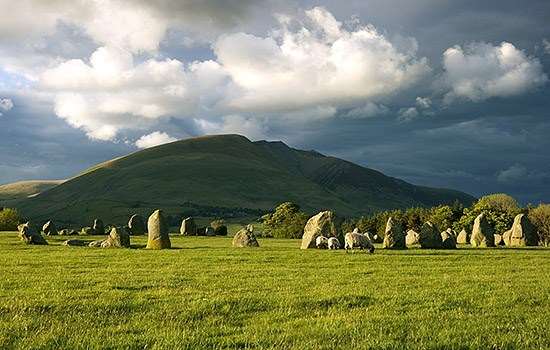
Today the henge earthworks are eroded and have been damaged by quarrying and ploughing. The northern henge is relatively well preserved, however, as its dense tree cover has protected it from intensive agriculture. Its surviving earthworks show the impressive scale of the monuments when they were first built. The inner ditch is still up to 2.6 metres deep and some 20 metres wide, and the main bank survives up to 3 metres high and 18 metres wide.
Earlier monuments
The central henge was built over a much earlier rectangular enclosure known as a cursus. Cursuses were elongated, relatively narrow enclosures, whose purpose is unknown, but it has been suggested that they were formalised routeways or barriers across the landscape. This one ran across the highest part of the plateau, and the line of the henges is perpendicular to it. The cursus was at least ¾ mile (1.2km) long and about 44 metres wide, and was defined by a bank and ditch which were interrupted by several causeways.
Although the Thornborough cursus has not been directly dated, elsewhere cursus monuments were built between about 3600 and 3400 BC, in the early Neolithic period.
The south-east entrance causeway across the inner ditch of the central henge was sited precisely where a causeway was located along the northern ditch of the cursus. This suggests that the older monument was deliberately incorporated into the layout of the henges. Unfortunately, much of the cursus was destroyed by quarrying in the 1950s.
Another possible cursus monument, seen as a rectangular ditch in aerial photographs, lies west of the northern henge. Also dating to the early Neolithic period in the area are an oval enclosure and a triple-ditched barrow containing several burials.
Worlds above and below
The henge monuments at Thornborough were built in open, dry grassland on an upland plateau with extensive views of the sky. The high banks of each henge would have blocked views of the surrounding landscape for people standing within them, except through the entrances. It has been suggested that these entrances were aligned with the movement of particular stars, such as Sirius, the sky’s brightest star in the constellation Canis Major. Its rising would have been framed within the southern entrance of all three henges.
The southern entrances of the northern and central henges are also aligned with the midwinter solstice sunrise. This was part of a wider practice of orientating Neolithic monuments to the solstices, including the passage tomb at Newgrange in Ireland and the stone circle of Stonehenge in Wiltshire.
It has been suggested that the white gypsum covering the henge banks may have been associated with the underworld, with the bones of the dead, or with the bright stars above. The fact that the Thornborough henges were built in one of the most subsidence-prone parts of the Gypsum Belt, where natural sinkholes and hollows are common, underlines the association with the world below. This active and unusual geological landscape may be one of the reasons people built monuments here.
A place of pilgrimage?
The location of the Thornborough henges seems to have been somewhere that people regularly gathered throughout the Neolithic period (about 4000–2400 BC). An extensive programme of fieldwalking (whereby archaeologists systematically walk the surface of ploughed fields and recover artefacts) has identified scatters of worked flint and chert – both fine-grained stones which were used to make tools and weapons. These scatters, found mainly near the river, indicate the sites of early Neolithic temporary settlements.
However, in the late Neolithic the area seems to have been kept clear of everyday debris, with occupation instead concentrated at four sites around the edge of the plateau. At Nosterfield, for example, to the north-west, there was a scatter of flint and chert associated with several pits and hearths. Finds from these occupation sites include chert from the Pennines and flint from the Yorkshire Wolds and coast.
This suggests that people were travelling to the monument complex from some distance, perhaps to take part in building projects and ceremonies. These patterns of long-distance movement have been identified at other late Neolithic monument complexes, such as at Ness of Brodgar on Orkney, at Avebury in Wiltshire, and probably at Rudston in East Yorkshire.
Bronze Age burials
In the early Bronze Age (about 2400–1500 BC), the Thornborough henges remained important, with several round barrows – mounds that usually covered graves or burials – built nearby. Between the central and south henges is a low mound known as the Centre Hill. When the archaeologist WC Lukis opened it in 1864, he found fragments of human bone in a wooden ‘coffin’ with a pottery vessel and flint tool. This was probably an early Bronze Age burial, although geophysical survey suggests that this barrow might have been built over an earlier, Neolithic structure.
Ten further early Bronze Age burial mounds and several ring ditches (circular ditches, usually surrounding a burial) are scattered across the landscape, including a group of three at Three Hills Group. Their upstanding earthworks have been destroyed by ploughing.
Also probably of this date are two double alignments of pits, which would have held timber posts, near the henges. Excavations at the one near the south henge have shown that it was 350 metres long, and probably erected between 1800 and 1600 BC. These ‘avenues’ may have been built to guide people’s movements, or make links between monuments. The southern avenue ends near a round barrow.
A wider complex
The complex of monuments at Thornborough does not occur in isolation. It is part of a more extensive cluster of Neolithic and early Bronze Age monuments found along a 7½ mile (12km) stretch of the river Ure, parallel with the modern A1 road. The Ure was probably a key route between the central Pennine Hills to the west and Yorkshire’s low-lying vales to the east.
Further south there are henges at Nunwick, Hutton Moor and Cana Barn, very similar to those at Thornborough, along with round barrows, pit alignments and enclosures, and evidence for extensive prehistoric settlement. Finally, the three standing stones of the Devil’s Arrows lie just south of the river Ure and share roughly the same alignment as the three henges at Thornborough.
A threatened landscape
By the mid 20th century sand and gravel extraction had destroyed about 13 hectares (32 acres) of land around the Thornborough monuments, including areas within 600 metres of the central and south henges. This resulted in the loss of many archaeological features, including most of the main cursus monument. The cursus had only recently been discovered by JK St Joseph through aerial photography, and was not protected by law. Rescue excavations were only possible at the western terminal in 1955 before it was destroyed.
More recent extraction quarries at Nosterfield and Ladybridge to the north of the complex were much larger, covering nearly 182 hectares (450 acres). However, this time archaeological excavation and recording preceded the quarrying. This led to many new discoveries including Neolithic pits and scatters of flint – evidence for a settlement contemporary with the henges.
The earthwork henges have suffered in other ways: the central henge was used as a munitions dump during the Second World War, and a section of the south henge bank was deliberately bulldozed in the 1960s.
Future research
The monuments have seen relatively little archaeological excavation, although some small trenches were dug by N Thomas in 1952. A major research programme between 1994 and 1998 included extensive geophysical and topographic surveys, as well as limited excavations at the central and south henges, one of the double pit alignments, the early Neolithic oval enclosure and a triple-ditched round barrow. The results of this project were published in a major monograph in 2013.
No archaeological work has taken place at the Thornborough henges since, and there are still many unanswered questions about the henges and their associated monuments. When exactly were the henges built? Did they have several phases of construction? What features were inside? Does the Centre Hill cover a Neolithic monument? Was there definitely a northern cursus? What more can we learn about the nearby settlements and where the people who bulit the henges might have come from?
Now that the future of the henges is secure, we can turn our attention to these questions, and use new technology to help us learn more about these fascinating and important monuments.
A special place
Thornborough remains a sacred landscape and place of spiritual power for groups who continue to worship here. The Pagan May Day festival, Beltane, and the autumn equinox festival, Mabon, are celebrated here each year.
Image: Celebrating the opening of the northern henge in September 2024
Further reading
Jan Harding et al, Cult, Religion, and Pilgrimage: Archaeological Investigations at the Neolithic and Bronze Age Monument Complex of Thornborough, North Yorkshire, CBA Research Report 174 (York, 2013)
Historic England, Prehistoric Henges and Circles, Introductions to Heritage Assets (Swindon, 2018)
Jan Harding, ‘Henges, rives and exchange in Neolithic Yorkshire’, in Image, Memory and Monumentality: Archaeological Engagements with the Material World, ed A Meirion Jones et al (Oxford, 2012), 43–51
Find out more
-

Visit Thornborough Henges
Find out how to visit this unique cluster of Neolithic monuments, which are sometimes described as the ‘Stonehenge of the North’.
-

Audio guide to Thornborough Henges
Download the free Bloomberg Connects app for our digital guide to Thornborough, including an audio tour of the henges.
-
Prehistoric Monuments
England’s prehistoric monuments span almost four millennia. Discover what they were used for, how and when they were built, and where to find them.
-

What is a henge?
Some of the most iconic Neolithic sites in England are henges, but what actually is a henge?