Description of Birdoswald Roman Fort
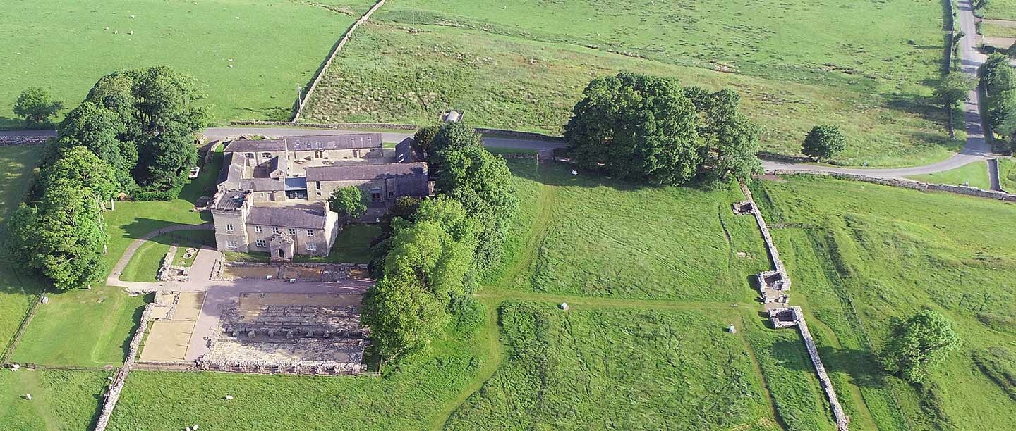
The visible remains at Birdoswald bear witness to all parts of its 1,800-year history – from the complete circuit of Roman fort walls, Roman granaries and post-Roman hall buildings to the foundations of a medieval tower house, a 16th-century bastle house and a Victorian romantic landscape.
The fort’s setting
Birdoswald lies in a narrow corridor between Hadrian’s Wall to the north and, to the south, a steep cliff above a meander of the river Irthing. The views southwards from the cliff edge over the river to the hills beyond and the ridge of the Whin Sill are stunning.
Hadrian’s Wall abutted the northern corners of the fort, and stretches of it can still be seen to the east and west.
Fort walls and gates
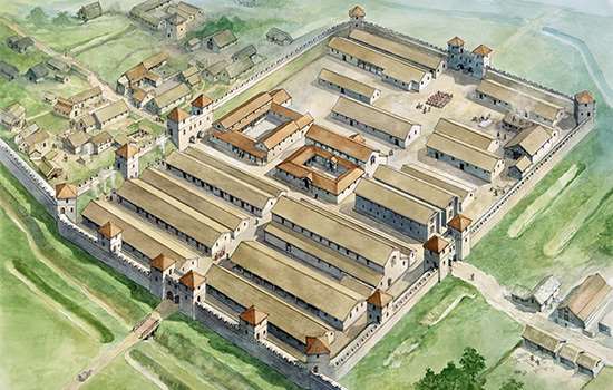
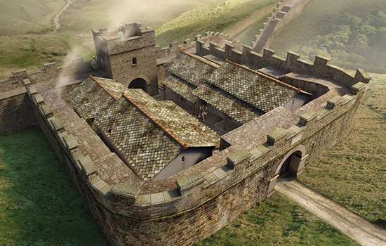
The fort was of the standard ‘playing card’ plan for Roman forts, a rectangle with rounded corners. Apart from the north-east corner, where the modern road cuts across Hadrian’s Wall, the fort walls are completely exposed. These were backed with an earth rampart and would have been some 4–5 metres high. In each corner was an angle tower, and interval towers were provided north of the east and west gates.
There were six gates, of which all but the north are visible. The four main gates – one on each side – were of a standard pattern of a double portal flanked by towers. Two additional single-portal gates were provided on the east and west sides, and are a relic of the early plan for a projecting fort like that at Chesters. The main east gate is the best preserved on Hadrian’s Wall, with one voussoir (wedge-shaped arch stone) surviving.
On the east wall there are traces of many repairs and rebuildings. Several of the towers around the fort were later used as bakehouses, and typical circular Roman ovens can be seen.
The fort interior
The multi-layered landscape within the fort walls is a product of 1,800 years of occupation.
In the Middle Ages and later, the walls acted as a useful enclosure. As we see it today, Birdoswald is a Victorian romantic landscape. The walls were excavated in the mid 19th century to provide a classical frame for the mock-medieval farmhouse with its tower, built in 1858. The area in front of it, formerly its garden, is the part of the fort interior that has been excavated.
The fort was built across a pronounced dip, with buildings terraced uphill to north and south. Thus the south granary wall, just south of the main west gate, is 2 metres high from the original surface, but Roman ground level at the south gate is at the present surface level. The buildings have been buried by the natural movement of soil and building debris downhill through erosion.
On the rising land south of the excavated area, the east–west corrugations of medieval ridge-and-furrow ploughing are visible. To the east, substantial earthworks mark the site of the headquarters building (principia).
Within the excavated area lie the main west gate and the main street (via principalis). To the south of the street lie two substantial and well-preserved granaries (horrea). The area is laid out to show the important post-Roman timber buildings – one on the site of the north granary, and two smaller structures to the west – which are represented by modern timber posts.
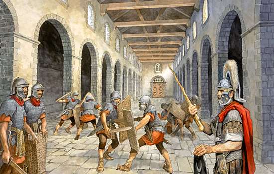
To the north of the street is a long narrow building used as a workshop (fabrica) in Roman times. The medieval tower house and the 16th-century bastle house were built on top of this and their remains are visible.
Outside the fort
To east and west Hadrian’s Wall survives up to 2.5 metres high, presenting one of the better preserved stretches.
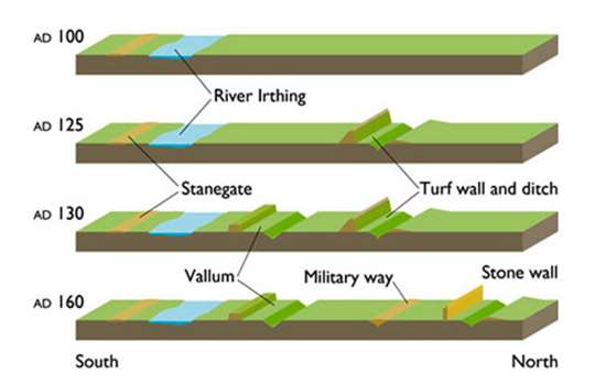
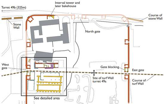
Some 325 metres west of Birdoswald is turret 49b (Birdoswald). In the original plan for Hadrian’s Wall, two turrets were intended for every Roman mile (about 1.48km), between small forts (milecastles). A few auxiliary soldiers lived or sheltered in these small watch towers.
Originally, the Wall in this area was made of turf and its course was further south, with an earlier turret (49a). Before the Wall was completed, it was decided to incorporate large forts, including Birdoswald. Later the turf wall was demolished and replaced in stone in its present position, and a new turret (49b) was built here.
This turret was built integrally with the stone Wall that replaced its turf predecessor on a more northerly line. It is not obvious from the road, which here runs along the north side of the Wall. The turret is 4 metres square internally, and survives to a height of three courses; the internal space is recessed into the thickness of the Wall. An entrance door in the south wall is offset from the south-east.
Turret 49b, as it may have appeared in the mid 130s AD. Move the sliding bar to reveal the turret interior. © Historic England/English Heritage Trust (illustrations by Peter Lorimer)
Further west two similar turrets, at Leahill and Piper Sike, can be seen by the roadside.
Milecastle 49 (Harrows Scar) lies 400 metres east above the bridge at Willowford which carried Hadrian’s Wall over the river Irthing. The Willowford sector also includes two turrets (48a and 48b) as well as some of the best-preserved parts of the Wall itself.
Geophysical survey in the 1990s revealed that large settlements surrounded the fort, and recent excavation (2021–4) east, west and north of the fort has provided important new understanding about this extramural settlement.
Find out more about Birdoswald
-
History of Birdoswald Roman Fort
One of 16 forts along Hadrian’s Wall, Birdoswald remained in occupation throughout the Roman period, and its layered history has made it an archaeologist’s paradise.
-
Uncovering the Secrets of Hadrian’s Wall
The remains of Birdoswald Roman Fort have revealed more about Hadrian’s Wall than any other site along Wall. Discover what some of the key finds tell us about the Romans and those who came after.
-
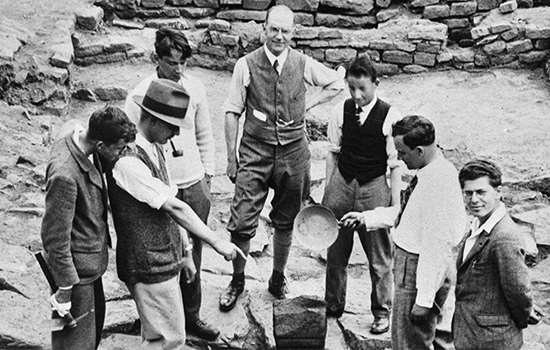
Research on Birdoswald Roman Fort
Birdoswald has been excavated many times over the course of more than a century. Explore the research undertaken by archaeologists throughout time.
-
The Significance of Birdoswald’s Archaeology
Birdoswald has produced more archaeological evidence for the phases of construction of the Wall than any other. Learn about its significance in the study of Hadrian’s Wall as a whole.
-
Sources for Birdoswald Researchers
A comprehensive list of the key material, visual and written sources for the study of Birdoswald.
-
Plan of Birdoswald Roman Fort
Download a PDF plan showing the visible remains the fort and how it developed over time.
-
Buy the Guidebook
This guidebook features a tour of the site and a comprehensive history of Birdoswald Roman Fort.
-
Hadrian’s Wall: History and Stories
Discover the history of Hadrian’s Wall, the north-western frontier of the Roman Empire erected on Emperor Hadrian’s orders in AD 122.