Research on Wroxeter Roman City
Wroxeter’s importance as a major Roman city in Britain underlines the importance of continuing to research its past. Although this might suggest the need for further excavation, the high quality of preservation of the site makes this problematic, because excavation involves comprehensive destruction. Archaeologists therefore prefer to use science to see through the soil, and to study the huge and important resources stored in Wroxeter’s archives of finds and records.

Geophysical and aerial research
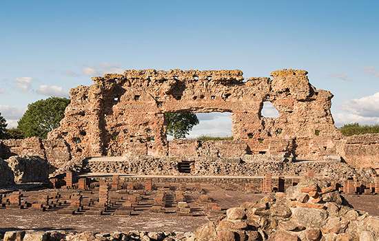
When considering research on an archaeological site, it is always best to consider first what strengths the site has in terms of its research potential. For Wroxeter, its main strength is, paradoxically, how little excavation has been carried out there. This, allied with the important fact that it remained largely deserted for two millennia, means that one can see, with a clarity that can be astonishing at times, the buildings that lie beneath the fields.
This clarity is a result partly of how the houses were built in the first place, and of the underlying geology of the site. The ordinary houses of Wroxeter were constructed largely of organic materials – timber and clay – which over time have been transformed into topsoil. The walls of the more substantial houses, however, stood on low stone walls, and it is these that show up so clearly in the geophysics and from the air when the ground suffers from drought conditions. As the soil dries, so the shallowly buried remains parch first, so lines of pale brown stand out against the greener grass: the patterns of walls, roads, temples and a myriad of other features slowly appears. These are best seen from the air, as admirably demonstrated by ex RAF-pilots who between the wars, and after the Second World War, regularly overflew the site in drought years and recorded in great detail the plan of the city under the soil. This work continues, but now we can use drones.
While we rely on drought for the best aerial results, geophysics (mostly gradiometry, which measures variability in the magnetism of the soil, or radar, which can look through the sequence of deposits) can be done at any time of the year. The clarity of this research has enabled us to develop a deep and broad-brush understanding of how the city developed.[1]
The role of excavation
While aerial archaeology and geophysics have provided us with the outline of the city’s history and development, only archaeology can provide the necessary detail of dating and evolution of its buildings. Recovery of artefacts and ecological information, such as animal bones, seeds and, occasionally, timber, in association with the remains of buildings and other structures, allows us to develop a nuanced understanding of how the city was constructed, used and modified through time. Without a written record, which archaeology is rarely able to supply, we can only generalise about how people lived, but sometimes we can arrive at a detailed awareness of how people used the spaces they lived in.
Archaeology is also responsible for some remarkable discoveries in the city, and for recovering the names of the few people we know who once lived there. Most of these last are soldiers who served in Wroxeter’s fortress and whose tombstones can be seen in the Shrewsbury Museum and Art Gallery. Also in the same location are the Wroxeter mirror – a stunning piece of late Roman silverware – and the Forum Inscription, a cast of which has pride of place in the site museum. Both these finds were made during the excavation led by Professor Donald Atkinson of the University of Manchester between 1923 and 1927. He also found a bronze discharge certificate in the same excavations, issued to an army veteran who, on retirement, seems to have stayed on in the city.[2]
Wroxeter’s hinterland
While study of the city has been comprehensive, the area outside the city, which was essential for its economic support, is also of interest to archaeologists. It too has produced evidence, especially through the work of the Wroxeter Hinterland Project (1994–7). This cast light not only on the farms and settlements around the city, but also on the fields and trackways that provide evidence for where the city’s food was grown.
The city’s cemeteries lay outside its walls too, as they did for other Roman towns and cities, and some of these have been investigated, along with a roadside shrine dedicated to an unknown god.
On the flood plain of the river Severn there is evidence for seasonal work – tile and pottery production that could take place in the hot summer months and meet the city’s needs.
These discoveries have given us a deeper and richer understanding of Wroxeter’s hinterland and of the relationship between the city and the landscape around it.[3]
Finds archive
Visitors to the site museum and Wroxeter, and to the Shrewsbury Museum and Art Gallery, will see on display many objects that have been found at Wroxeter and that help to tell its story. These are, however, only the tip of a large iceberg of evidence that sits in the stores of both English Heritage and the Shrewsbury Museums Service. English Heritage alone holds more than 35,000 individual artefacts, about a ton of animal bone and 1.5 tons of pottery.
These objects are kept for research and engagement. The information on where they were found is an intrinsic part of their value to scientific study, not least because when first collected, the science enabling their study did not exist. A good example of this is the animal bone and environmental evidence collected from the baths basilica site (excavated 1966–90). At the time of collection, it was not possible to date this material scientifically.
But now, 30 years later, technology has advanced so far that samples of around 1 gram can be radiocarbon-dated. This has enabled English Heritage and Historic England to completely re-date the baths basilica site: the as yet unpublished results of this research have completely changed our understanding of the latest levels of the site’s occupation. Without the retention of this archive in the best possible conditions, it would not have been possible to do this work. Other projects are in the pipeline; the research never ceases.
Footnotes
1. RH White, C Gaffney and VL Gaffney, with A Baker, Wroxeter, the Cornovii, and the Urban Process: Final Report on the Wroxeter Hinterland Project 1994–1997, volume 2: Characterizing the City (Oxford, 2013).
2. RH White, Wroxeter: Ashes under Uricon – A Cultural and Social History of the Roman City (Oxford, 2022), 17–25.
3. VL Gaffney and RH White, with H Goodchild, Wroxeter, the Cornovii, and the Urban Process: Final Report on the Wroxeter Hinterland Project 1994–1997, volume 1: Researching the Hinterland, Journal of Roman Archaeology Supplementary Series 68 (Portsmouth, Rhode Island, 2007); White, Gaffney and Gaffney, op cit.
Find out more
-
History of Wroxeter Roman City
Founded in the mid 1st century AD, Wroxeter was one of the largest cities in Roman Britain and is exceptionally well preserved.
-
Significance of Wroxeter Roman City
Wroxeter is probably the best-preserved Roman city in Britain, as well as one of the largest, although only a fraction of it can be seen today.
-
EXPLORE ROMAN BRITAIN
Browse our articles on the Romans to discover the impact and legacy of the Roman era on Britain’s landscape, buildings, life and culture.
-
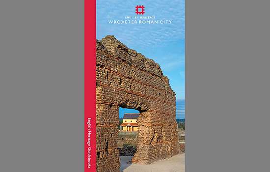
Buy the guidebook
The guidebook provides a full tour of Wroxeter Roman City and explains the complex history of its rise and decline.
-
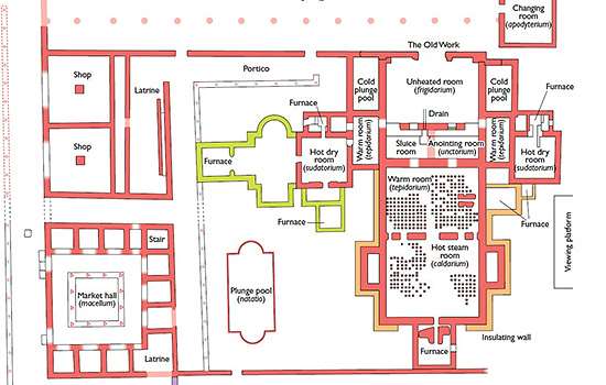
Download a plan
Download this pdf plan of the baths complex at Wroxeter to see how the buildings developed over time.