Description of Chesters Roman Fort
Remains survive from various periods in the 300-year life of the fort, but all the gates, the external baths and much of the headquarters date from the reign of Hadrian. Most of the fort’s buildings are still buried, and with a few dramatic exceptions only the lowest parts of the walls have survived stone-robbing and ploughing since the Roman period.

Setting
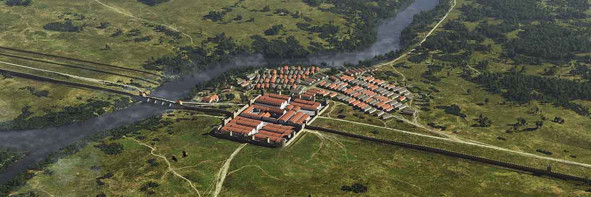
Chesters lies on a terrace on the west side of the wooded valley of the North Tyne, a major river crossing the line of Hadrian’s Wall, at a point just over 27 miles from the eastern terminus of the Wall at Wallsend.
Fort Layout
The fort is of the usual playing-card shape, covering 2.32 hectares. The fort wall (of which very little is exposed) was of stone.
The fort projected north of the Wall, with three of its main gates lying on the north side and only one to the south. All four of these gates, each with two portals and flanked by towers, are visible, and they are among the most instructive to be seen anywhere. One side of the east gate stands to the height where the portal arch began to spring.
Two lesser single-portalled gates (only the eastern one is visible) gave access to traffic running east–west, provided here because the main side gates were isolated on the north side of Hadrian’s Wall.
Fort Interior
Most of the fort interior is unexcavated, the visible selection of buildings resulting from the excavation campaigns of John and Nathaniel Clayton between 1843 and 1893.
The central headquarters building (principia) exhibits its original and very elaborate Hadrianic plan, with colonnaded forecourt and basilica (hall). The latter was entered by no fewer than five doors from the court and colonnades and by two further doors in its ends. At the rear of the building are five rooms that formed the administrative heart of the fort; the central room is the regimental shrine, or aedes. From here, stairs lead down to a strongroom or treasury, a later insertion and a remarkable survival, with its vaulted roof still intact.
East of the principia are the impressive but poorly understood remains of the commanding officer’s house (praetorium). A large set of baths to the east was perhaps provided for the garrison in the later Roman period rather than for the private use of the commandant as traditionally thought.
Two opposing barrack blocks, parts of which are visible in the north-east part of the interior, are the clearest examples of auxiliary barracks to be seen anywhere in the empire.
Outside the fort
The external baths, close to the river 70 metres east of the fort, were uncovered in 1884–5 and constitute the most complete set of Roman baths to be seen in Britain. The baths are of Hadrianic date with many later additions and alterations.
Near the baths is a viewing platform overlooking the site of the west end of the Roman bridge over the North Tyne. Much more is to be seen of the bridge by following a path from the modern bridge at Chollerford to view the superb remains of the eastern bridge abutment uncovered by John Clayton in 1860 on the other side of the river.
Although there is nothing to see on the ground, the plan of an extensive civilian settlement (vicus) which surrounded the fort on the south side of Hadrian’s Wall is known from aerial photographs. Further details have been revealed by geophysical survey, but the vicus has never been excavated.
READ MORE ABOUT CHESTERS ROMAN FORT